To understand the full benefits of EMODnet, users are kindly asked to describe how EMODnet supports them in their daily work and activities.
If you have developed an application using EMODnet products that you would like to share with us or if you use EMODnet data for other purposes, submit your use case by contacting secretariat@emodnet.ec.europa.eu.
EMODnet Seabed Habitats data enabled the mapping of potential disturbance to benthic habitats due to fishing in the north-east Atlantic. The assessment was part of the wider OSPAR Intermediate Assessment 2017, which evaluates the status of the marine environment of the North-East Atlantic.
Orsted Power (UK) Ltd are responsible for the development, construction and operation of offshore windfarms across Europe. Hornsea Project Three has been proposed in the North Sea, off the North Norfolk Coast, with the potential to be generating up to 2,400 MW of electricity, the average daily needs of approximately 2 million UK homes.
The pan-European map presenting the distribution of modelled broad scale seabed habitats (EUSeaMap v2016) made available through the EMODnet Seabed Habitats project, was crucial in the assessment recently performed by ISPRA in collaboration with the European Environment Agency to compile information on the distribution of all marine broad-scale habitats for the whole Western Mediterranean basin.
NIVA Denmarkis a regional office under the Norwegian Institute for Water Research (NIVA), an institution with over 50 years experience in applied aquatic science. NIVA Denmark is focussed on applied research in aquatic ecosystems and evidence-based consultancy. Their key areas of research include eutrophication, hazardous substances, biodiversity and ecosystem health, as well as the implications of multiple human activities in aquatic environments.
Undertaking a regional cumulative impact assessment requires a vast amount of spatial data. EUSeaMap v2016 was a key data source for defining ecosystem components in reporting on the 2011-2016 HELCOM ‘State of the Baltic Sea’.
The EMODnet Chemistry portal has tested the application of INSPIRE Data Specifications to model nutrient data (MSFD Criterion D5C1 “Nutrients concentrations in water”) in the Mediterranean Sea. The use case builds on the Technical Guidelines related to Environmental Monitoring Facilities (EMF) and Oceanographic Geographical Features (OF) themes and to the Observations and Measurement (O&M) data model and was developed in collaboration with the SeaDataCloud and MEDCIS projects. The exercise demonstrated the completeness of EMODnet Chemistry metadata with respect to INSPIRE requirements and the feasibility to map EMODnet to INSPIRE models.
It is not an easy task for a met-ocean data user to clearly understand which data have been used in the calibration / validation phase of the hindcast database, the use of EMODnet Physics as the main source for observed marine data collection is highlighted in the description of the DHI’s MWM product.
The availability of both depth data and geology data from one centralised point of contact (EMODnet) enabled Irwin Carr Consulting, an SME that provides specialist services that range from environmental noise, air quality, building acoustics and underwater noise, to be competitive and have efficient turn-around times on marine projects that otherwise would be delayed by prohibitively costly marine mapping work prior to impact assessments.
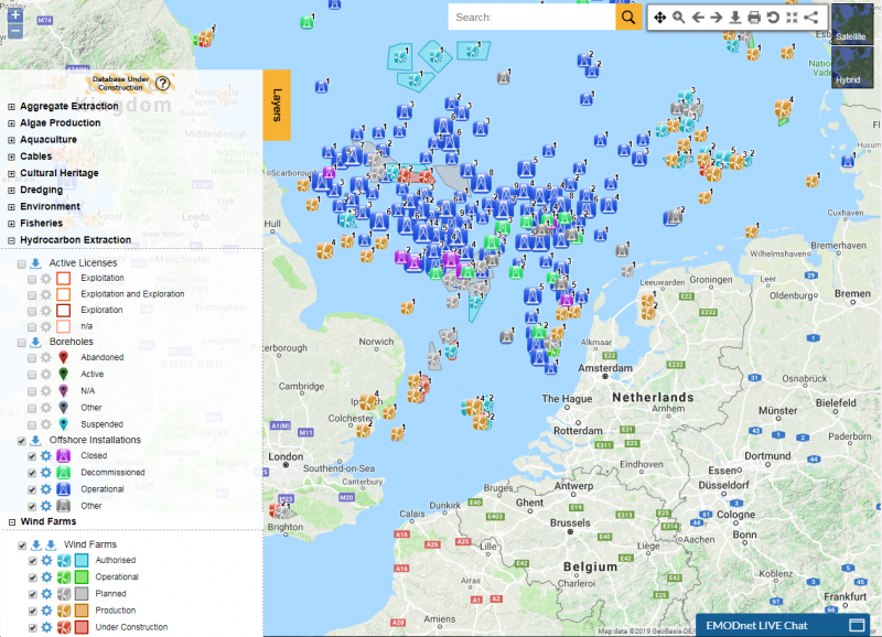
The EMODnet Human Activities portal has become a vital tool for C2Wind, a Danish company working in the wind industry. Wind farm and hydrocarbon extraction datasets are the most commonly explored datasets, identifying locations of already existing structures. Additional datasets on occasion are surveyed to provide the full extent of human activities. This crucial information is used in the preliminary phases of projects, determining areas of interest for the development of wind farm projects.
The development of EMODnet standard classifications for the various categories of seabed substrate allowed a digital map layer covering Russian, Finnish and Estonian waters to contribute towards the Gulf of Finland assessment published in 2016. This was one of the most important outcomes of the Gulf of Finland Year arranged by the three countries in 2014.