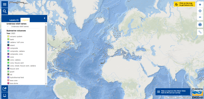
Map of the Week – Seamount and Ocean Seabed

Have you heard that a new seamount has been discovered in international waters off Guatemala in November 2023 (1)? Besides this seamount, in 2023, international teams of scientists also discovered the first pristine deep-sea coral reefs in the Galápagos Islands Marine Reserve that crest the ridge of an unmapped submerged volcano (2), two other deep-sea coral reefs and two additional uncharted seamounts (3), as well as a new high-temperature hydrothermal vent field in the waters surrounding the Galápagos Islands (4)!
A seamount is a feature that must rise at least 1,000 metres above the surrounding seafloor. Most seamounts are remnants of extinct volcanoes, while some are still active and growing. Seamounts function as ‘Oases of Life’, as they have higher marine species diversity compared to the seafloor around them (5). Explore the Map of this week to check out the undersea volcanoes, seamounts, and other features! The EMODnet Bathymetry World Base Layer, with the undersea relief names map layer, show that the seafloor consists of numerous complex and varied geographical features. Despite their abundance, the vast majority of them remained unexplored and not mapped to modern standards!
Even after more than a century of seafloor mapping effort, the ocean floor still has much mysteries to be revealed! In fact, as of 2023, only one-quarter of the seabed is mapped (6). The Ocean covers 71% of the Earth’s surface. It plays a fundamental role in supporting life, regulating climate, fostering economic prosperity, and serving as a reservoir of resources as well as energy. Bathymetric data are key in marine geology and geophysics. A vital historical example is Bruce Heezen and Marie Tharp's mapping of the Atlantic Ocean floor more than half a century ago, leading to paradigm shifts in Earth processes towards the seafloor spreading and plate tectonic theories! Seafloor shape is essential for understanding ocean circulation patterns, which impact global climate processes and contribute to numerical modeling for tsunami forecasting. Additionally, mapping the ocean floor is crucial for diverse purposes, including marine spatial planning, navigation safety, climate change assessments, and the study of marine ecosystems (7).
Are you interested in learning more about the seabed?
- Learn more about the Seabed 2030 Project! Seabed 2030 was initiated in 2016 and is led by the Nippon Foundation and the General Bathymetric Chart of the Ocean (GEBCO ). The objective is to catalyse the mapping of the entire ocean floor, with the goal of seeing 100% of the World Ocean floor topography mapped by 2030.
- Listen to episode 4 of the Seabed 2030 Podcast.
- Explore the BathyGlobe global map, developed by the Center for Coastal Ocean Mapping at the University of New Hampshire.
- Read the ‘What is a Seamount? ’ and ‘Seamounts: Oases of Life ’ factsheets produced by NOAA Ocean Exploration , to understand more about these submarine features!
The data in this map are provided by EMODnet and the National Geospatial-Intelligence Agency .
- https://schmidtocean.org/massive-new-seamount-off-guatemala/
- https://www.darwinfoundation.org/en/blog-articles/887-scientists-discover-pristine-deep-sea-coral-reefs-in-the-galapagos-marine-reserve
- https://schmidtocean.org/healthy-deep-sea-coral-reef-and-new-seamounts-in-the-galapagos/
- https://schmidtocean.org/scientists-locate-new-hydrothermal-vent-field-using-state-of-the-art-mapping-technology/
- https://oceanexplorer.noaa.gov/facts/seamounts.html
- https://seabed2030.org/our-mission/
- https://seabed2030.org/2023/06/21/the-nippon-foundation-gebco-seabed-2030-project-roadmap-for-future-ocean-floor-mapping/
