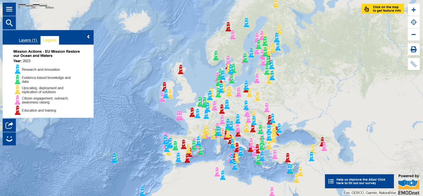
Map of the Week – European Union Mission Restore our Ocean and Waters

It has been an amazing week! From 27 to 30 November 2023, the European Marine Observation and Data Network (EMODnet) community met in Brussels for the EMODnet Open Conference and Jamboree . The event brought together over 340 EMODnet partners, associated partners and wider stakeholders from around the world. Plenary sessions were livestreamed.
The EMODnet network is supported by the European Union’s Integrated Maritime Policy. It gathers organisations that work together to observe the sea, process the data according to international standards and make that information freely available as interoperable [1] data layers and data products. EMODnet provides access to European marine data across seven themes: bathymetry, biology, chemistry, geology, human activities, physics and seabed habitats. Thanks to EMODnet, scientists and professionals can easily access in situ data (data directly collected at sea, for example by means of oceanographic instruments, sampling or observations) that is important for their work. They can also submit their data through EMODnet Data Ingestion to share their data with others. This is essential for everyone to work together to get a better understanding of the ocean. The EMODnet philosophy "collect once and use many times" benefits all marine data users, including policy makers, scientists, private industry and the public. Rapid access to reliable and accurate information is vital in addressing threats to the marine environment, in the development of policies and legislation to protect vulnerable areas of our coasts and the ocean, in understanding trends and in forecasting future changes. During the Open Conference and Jamboree, participants discussed EMODnet’s evolution to-date and how EMODnet can further contribute to a digital and green future.
Did you know that the European Atlas of the Seas is powered by EMODnet? To enable all of us to access marine data, whether or not our work is connected to the ocean, the European Commission has developed the European Atlas of the Seas as an ocean literacy, an education and a communication tool. Over half of the map layers in the Atlas are developed on the basis of EMODnet data. The Atlas also includes map layers based on data from a diversity of data providers including the Copernicus Marine Service, the European Environmental Agency (EEA), Eurostat and the Joint Research Center (JRC).
The European Atlas of the Seas was featured in several components of the EMODnet Open Conference and Jamboree, including the Virtual Exhibition , the Jamboree session “Citizen Science and EMODnet” on 28 November 2023, the Townhall ‘EMODnet, EU Mission Ocean and wider society’ on 29 November 2023 and the panel “EMODnet by and for wider society” within the session “EMODnet impact for society” on 30 November 2023. These sessions showed how EMODnet can support the European Union Mission “Restore our Ocean and Waters” and included discussions on the benefits of the contribution of citizens and citizen science projects to data sharing and how this could be done. The Atlas poster was presented to the audience during the EMODnet Community poster pitches. Both the Atlas Teachers Corner and the My Maps tool were highlighted as tools to support education.
Speaking about the European Union (EU) Mission “Restore our Ocean and Waters”, have you seen the latest update of the Atlas’ map layer ‘Mission Actions - EU Mission Restore our Ocean and Waters’? The Mission Actions present the joint efforts to achieve the three objectives of the Mission Restore our Ocean and Waters by 2030 to:
- Protect and restore marine and freshwater ecosystems and biodiversity, in line with the EU Biodiversity Strategy 2030;
- Prevent and eliminate pollution of our ocean, seas and waters, in line with the EU Action Plan Towards Zero Pollution for Air, Water and Soil;
- Make the sustainable blue economy carbon-neutral and circular, in line with the proposed European Climate Law and the holistic vision enshrined in the Sustainable Blue Economy Strategy.
To reach these objectives, the Mission is also putting in place two enablers:
- Digital Ocean and Water Knowledge System;
- Public mobilisation and engagement.
Each of the lighthouses in the map represents an action pledged by a signatory of the Mission Charter. Click on the symbols to read the details about the actions! EMODnet submitted an action — Evolving marine data and knowledge services — in early 2023, committing to continuously delivering the access and provision of marine knowledge to underpin the core objectives of the EU Mission. Can you find EMODnet’s pledged action on the map (hint: the EMODnet Secretariat is based in Belgium and the action is found in the category ‘Evidence-based knowledge and data’)?
Wish to learn more?
- Make sure that you visit the EMODnet Virtual Exhibition and enjoy discovering the content of the Atlas room (turn to the right twice when you enter the Virtual Exhibition)!
- Explore the Map of the Week to discover the Mission Actions pledged by stakeholders across Europe to achieve the objectives of the Mission ‘Restore our Ocean and Waters’ by 2030.
- Learn about the European Marine Board’s Artist-In-Residence Programme , the Educational Passages Miniboat programme , Sailing4Science and the Remedies project mentioned at the Townhall ‘EMODnet, EU Mission Ocean and wider society’.
- Discover the citizen science initiatives from Erasmus Maris and Outdoor Portofino presented during the panel session “EMODnet by and for wider society”.
Following four days of very interesting discussions, insightful plenary sessions, energetic townhalls and manifold opportunities for dialogues, the 2023 EMODnet Open Conference closed after a forward looking session on "EMODnet Evolution" with a great panel of experts and a dynamic Call to Action for EMODnet's continued growth and evolution towards 2035!
The data in this map are provided by the European Commission.
[1] Interoperability is the ability of two or more systems, or components to exchange information, and to use the information that has been exchanged (https://emodnet.ec.europa.eu/en/seabed-habitats-glossary#sbh-glossary-i) .
