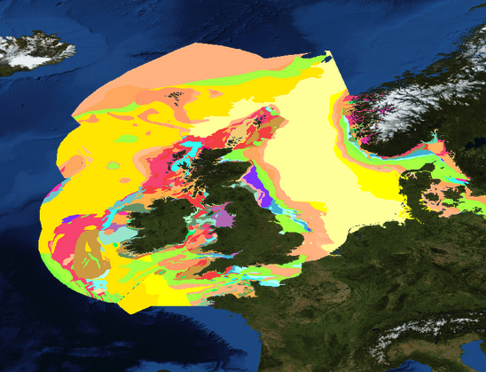
EMODnet Geology has succeeded in bringing together harmonised offshore data including sea-floor geology, seabed substrates, rates of coastline migration, geological events and probabilities, mineral resources and submerged landscapes.
EMODnet Geology Portal consolidates the existing data products with higher resolution and more contents. New services are being built, so users can investigate and search for borehole and grab sample data, seismic survey data, and multibeam survey data using interactive maps and tools.
EMDOnet Geology aims at providing harmonised information on marine geology in Europe for the entire European seas.
Objectives
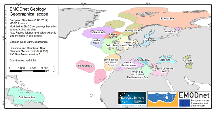
The geology portal provides open access to geological data and metadata held by various geoscience organisations in Europe, lending us a better understanding of the ocean seafloor and its resources. The data is delivered in accordance with international standards, and geological data products compiled at scales of 1:1,000,000, 1:250,000 and 1:100,000 or finer where the underlying data permit. A geographical coverage includes all the regional seas in Europe, Caspian Sea and the latest addition, Caribbean Sea.
Data Products
EMDOnet Geology aims at providing harmonised information on marine geology in Europe for the entire European seas. The following data products are already available for Geology:
- Seabed Substrates and Sedimentation rates;
- Sea-floor Geology: Pre-Quaternary geology (incl. lithology and stratigraphy), Quaternary geology and geomorphology;
- Coastal Behavior: Satellite and Field data based Coastal behavior, Coastal types;
- Geological Events and Probabilities (e.g. earthquakes, submarine landslides, volcanoes, and Quaternary tectonics, landslide susceptibility);
- Marine minerals (e.g. aggregates, hydrocarbons, gas hydrates, marine placers, polymetallic nodules);
- Submerged landscapes;
- Entity indexes (borehole and grab samples, Seismic and multibeam survey data).
Background
Phase I (2009-2012)
During the preparatory phase of EMODnet (Phase I), 14 organisations from 14 countries demonstrated that geological information could be compiled and harmonised at 1:1 million scale to provide map information and supporting data for Northern parts of the regional seas of Europe.
The first phase of the project focused on identifying and assessing the geological information that exist in each country represented in the project and making data freely available at the web portal. All the themes, especially Seabed substrates, Seafloor geology and Coastal behaviour, made significant progress assembling and delivering the data that exists for the European seas.
Phase II (2013-2016)
Phase II started in October 2013. Extended consortium consisted of 36 partners who were able to provide geological information from all the European seas and, by including organisations from Iceland, Norway, and Russia, to expand the information coverage into the North Atlantic Ocean and to the margins of the Arctic (Barents Sea and White Sea). In addition, national and regional networks were established for the better co-ordination of information for example in Iceland, Italy and in the Adriatic and North Sea regions.
The geological data that were compiled in the preparatory project phase I and in the phase II, included Seabed substrate at 1:250 000 scale and at 1:1 000 000 scale where the higher resolution data was not available, Sedimentation rates, Seafloor geology – lithology and stratigraphy, Coastal behaviour, Mineral occurrences (e.g. oil and gas, aggregates, metallic minerals) and Geological events and probabilities (e.g. earthquakes, submarine landslides, volcanic centres). Besides pre-Quaternary seafloor geology, Phase II also included the start of compilations of Quaternary information, and agreement on geomorphological information that should be included in the EMODnet-Geology outputs.
Phase III & III.2 (2017-2019 & 2019-2021)
Phase III of EMODnet Geology project started 12. April 2017 with same consortium as in phase II, added with experts from three universities (Dipartimento Scienze della Terra Università La Sapienza, Roma, Italy; Department of Geology, University of Tartu, Estonia; Foundation for Research and Technology Hellas - Institute of Computer Science, Crete, Greece) in order to fulfil the new task in this phase: Submerged Landscapes. The third phase of the project focused on compiling and delivering map information for each work package but this time in a higher resolution, 1:100,000 or finer where the underlying data permit. The formerly used EUROSION data for coastal behaviour was updated with new field and satellite information, new focus was put on coastal resilience. The EMODnet Geology portal was moved to the EGDI (European Geological Data Infrastructure) portal which considerably improved the quality and performance of the portal service.
Phase III was extended with a new contract into phase III.2 which included the same specifications, except that the geographical coverage of EMODnet Geology was extended into the Caspian Sea. The extension phase started 25. September 2019.
Phase IV (2021-2023)
Phase IV started with a new contract immediately after the phase III.2 contract ended on 24. September 2021. The specifications of the service contract were quite similar to the earlier phase but included a new deliverable; seabed erosion rate and the coastal behaviour deliverables were expressed as; migration direction, rate and volume, morphology, resilience. The geographical scope of EMODnet Geology was extended to the Caribbean Sea.
Partnership
The partnership consists of 40 partners or subcontractors from 30 countries. Most of them are geological survey organisations of all the maritime countries of the European Union. Twenty-four of the project partners are also members of the Geological Surveys of Europe (EuroGeoSurveys), which exists to promote the work of the geological surveys and therefore provides a long-term association under which the project partners collaborate.
As the principal holders of marine geological information, the partnership also ensures that data from all of the European regional seas, as well as the Caspian Sea and the Caribbean Sea are provided to the project. The project will build on information primarily held by the project partners but will also connect to other owners of information using Web Map Services (WMS), as for example by linking to the European-Mediterranean Seismological Centre (EMSC), which compiles information on earthquake activities. By doing so, the project will not recreate information that is held elsewhere. The development of a web delivery mechanism using open-source standards also aim to ensure the long-term sustainability of the project by delivering the best available and up-to-date marine geological information held by the project partners.
A characteristic of the EMODnet-Geology Project is that the focus is on harmonised interpreted map information rather than the underlying data that have been used to create the interpreted geological outputs. However, the web delivery system is designed to be able to access data catalogs of information held by each partner organisation and therefore has the potential to access more detailed information (maps and data) at national level. This aspect of the system is considered important to the long-term sustainability of the EMODnet Geology outputs as it will provide access to the national sources of information where the partner organisations maintain their information resources.
You can find the full and update list of the consortium on the following section of the website “Partners”.
Communication
In this section you will find thematic-specific communication material, and a direct link to the video gallery.