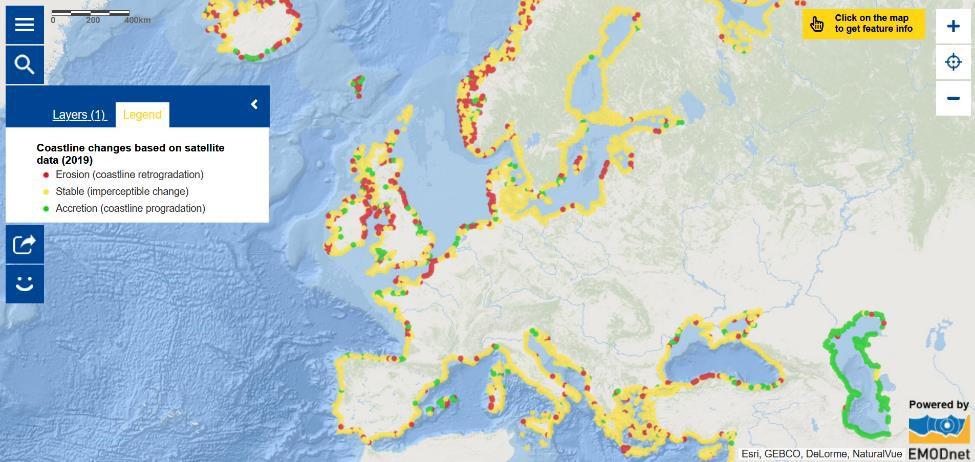
Map of the Week – Coastline changes based on satellite data

This week, the European Commission organised the launch event of the European Climate Pact. It is an opportunity for people, communities and organisations to participate in climate action across Europe. As part of the European Green Deal, it aims to become a lively space to share information, debate and act on the climate crisis, and offer support to grow and consolidate a European climate movement.
Oceans play a key role in regulating the climate. However, they are directly affected by climate change which is notably causing sea surface temperatures and sea levels to rise, as well as changes in geographical and seasonal distributions of marine and coastal species [1] and coral bleaching [2] . On average, since early 1993, global mean rate of sea level rise amounts to 3.3±0.3mm/yr.[2] Climate change aggravates coastal erosion as sea level rise, increased storminess, changes in prevalent wind directions and higher waves put Europe's coast under pressure. [3] The majority of the excess energy that accumulates in the earth’s system due to increasing concentrations of greenhouse gases is taken up by the ocean. [2] Furthermore, increasing concentration of CO2 in the oceans leads to ocean acidification. [2] The ocean-climate nexus is a global issue. It was addressed at the virtual EU International Ocean Governance Forum 2020 (IOG Forum) on 14-16 December 2020. The IOG Forum Discussion Paper points out that nature-based solutions offer solutions for ocean health, biodiversity, climate mitigation and adaptation and a huge range of co-benefits, particularly to coastal communities, in the form of coastal protection, decent work and sustainable tourism.
So, what can you do?
- Dive into the European Atlas of the seas to learn about coastal erosion.
- Discover initiatives developed to strengthen climate change adaptation with the European Climate Adaptation Platform Climate-ADAPT.
- Get involved in the European Climate Pact by becoming an Ambassador, making a pledge and/or organise Climate Pact satellite event.
- Learn about the upcoming Ocean Decade.
- Join the EU4Ocean Platform, the Youth4Ocean Forum or the Network of Blue Schools. Did you know that a Working Group on Climate and Ocean has been set up within the framework of the EU4Ocean Platform?
The Map of the Week will be on a winter break in the coming two weeks. We will be back with new oceans and seas updates on 8 January 2021. We wish you happy and safe holidays!
The data in this map are provided by EMODnet.
[1] https://www.eea.europa.eu/themes/water/europes-seas-and-coasts
[2] https://library.wmo.int/doc_num.php?explnum_id=10444
[3] https://ec.europa.eu/environment/iczm/coast.htm
